GEMSIS-Ionosphere
Model of Large-Scale Field-Aligned Currents
Empirical Model of Large-Scale Field-Aligned Currents
The realistic modeling of field-aligned currents is one of the essential parts for conducting space weather research from a deductive point of view. For this purpose, we have developed an empirical model of large-scale field-aligned currents (LSFACs) in collaboration with the Institute of Statistical Mathematics (ISM) and the Johns Hopkins University Applied Physics Laboratory (JHU/APL). This model is made by applying new statistical methods for a few hundreds of thousands data sets of field-aligned current observations obtained by the DMSP, DE2, and FAST satellites. The model is parameterized by the solar wind speed, the interplanetary magnetic field (IMF), the tilt angle of the Earth’s magnetic field, and the solar activity indices to give a realistic spatial profile of LSFACs. Modeling procedures from past studies tend to give much smaller intensities of LSFACs than those actually observed because they were constructed by averaging adjacent LSFAC sheets of opposite polarities. To avoid this weakness and give quantitatively appropriate intensities as well as spatially sharp boundaries of LSFAC sheets, the present model has adopted a new method in which positions of upper/lower latitude boundaries and intensities of LSFACs are averaged separately. The results were presented at several domestic scientific conferences/meetings.
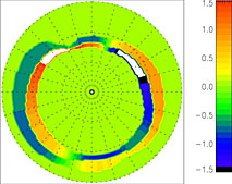
A resultant LSFAC structure of our empirical model for the southward IMF case was deduced from the magnetic field data obtained by the DMSP and the DE2 satellites. One of the advantages of the present model is to the ability to show sharp boundaries of LSFAC sheets as actually seen along individual satellite passes.
Direct Observations and Inversion Studies of the Auroral Current System
Auroras in the ionosphere (100-km altitude) are controlled by the magnetosphere through FACs. To date, FACs have been studied using two different methods: polar-orbiting satellite observations and the inversion of ground magnetic field data. Polar-orbiting satellite observations measure sheet-like FACs quite accurately. However, satellite observations are limited to the satellite trajectories. Statistical studies are thus required to obtain global maps of the FAC. Inversion of ground magnetic field data provides estimates of global snapshots of FACs. It is reported that direct observations and the inversion method yield different spatial distributions of FACs during disturbed periods. In the present study, we compared observed and estimated FACs. The inversion reproduced the spatial pattern of an observed 2-sheet FAC with peak values underestimated by 30-60%. For an observed four-sheet FAC, the inversion reproduced the outermost two sheets but failed to reproduce the innermost two sheets.